


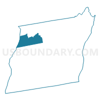
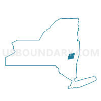
Voting District 090001, Albany County, New York
About
Outline

Summary
| Unique Area Identifier | 624595 |
| Name | Voting District 090001 |
| County | Albany County |
| State | New York |
| Area (square miles) | 23.14 |
| Land Area (square miles) | 23.01 |
| Water Area (square miles) | 0.13 |
| % of Land Area | 99.46 |
| % of Water Area | 0.54 |
| Latitude of the Internal Point | 42.66243780 |
| Longtitude of the Internal Point | -74.10958730 |
Maps

Graphs
Select a template below for downloading or customizing gragh for Voting District 090001, Albany County, New York


Neighbors
Neighoring Voting District (by Name) Neighboring Voting District on the Map
- Voting District 020002 020003, Albany County, NY
- Voting District 080023 080024 080028, Albany County, NY
- Voting District 090002, Albany County, NY
- Voting District 100001, Albany County, NY
- Voting District 160001, Schoharie County, NY
Top 10 Neighboring County Subdivision (by Population) Neighboring County Subdivision on the Map
- Guilderland town, Albany County, NY (35,303)
- New Scotland town, Albany County, NY (8,648)
- Berne town, Albany County, NY (2,794)
- Knox town, Albany County, NY (2,692)
- Wright town, Schoharie County, NY (1,539)
Top 10 Neighboring Unified School District (by Population) Neighboring Unified School District on the Map
- Guilderland Central School District, NY (36,131)
- Voorheesville Central School District, NY (7,226)
- Schoharie Central School District, NY (6,725)
- Berne-Knox-Westerlo Central School District, NY (6,602)
Top 10 Neighboring State Legislative District Lower Chamber (by Population) Neighboring State Legislative District Lower Chamber on the Map
Top 10 Neighboring State Legislative District Upper Chamber (by Population) Neighboring State Legislative District Upper Chamber on the Map
Top 10 Neighboring 111th Congressional District (by Population) Neighboring 111th Congressional District on the Map
Top 10 Neighboring Census Tract (by Population) Neighboring Census Tract on the Map
- Census Tract 7407, Schoharie County, NY (5,285)
- Census Tract 146.13, Albany County, NY (2,863)
- Census Tract 148.01, Albany County, NY (2,794)
- Census Tract 147, Albany County, NY (2,692)
- Census Tract 145.01, Albany County, NY (2,380)
Top 10 Neighboring 5-Digit ZIP Code Tabulation Area (by Population) Neighboring 5-Digit ZIP Code Tabulation Area on the Map
- 12009, NY (7,164)
- 12186, NY (6,277)
- 12053, NY (4,587)
- 12157, NY (4,061)
- 12023, NY (2,196)
- 12059, NY (1,632)